Death Valley, March 2006
We almost always travel somewhere for Michelle's birthday.
For 2006 we returned to Death Valley.
As on our previous trips, we flew to Las Vegas, rented a four-wheel-drive
car, then drove to the Valley.
4WD isn't needed unless you plan to explore the minor roads, but
we enjoy that, and we did a good bit of it this year.
In particular, we completed the trip from Saline Valley to the
Racetrack valley over the Hunter Mountain road.
(We attempted that last time but were forced to retreat because of
snow.)
It wasn't a great trip for photography.
Death Valley often has high winds and dust storms during the summer;
we didn't encounter any on previous winter and spring visits, but we
did this time.
Skies were hazy, the light was flat, sand was in the air,
and the wind was high enough at times to make it difficult to hold the
camera steady.
This trip we made the drive from Death Valley
to another one of our favorite areas, the Owens Valley.
The stark high desert scenery was well worth the effort, and the
roadside geology is a good introduction to the basin-and-range country.
We've heard about the plumes of dust and alkali that are blown off the
surfaces of the dry lake beds east of the Sierra, but this was the
first time we've seen them.
(Judging from their position against the backdrop of the Sierra as we
crossed the pass east of Keeler, the tops of the plumes from Owens Lake
may have reached 10,000 feet.)
Allen was interested to see Keeler and the Death Valley areas
where Erich von Stroheim's influential movie
Greed was filmed in 1924.
Once again we can recommend the restaurant at the Furnace Creek Inn,
and next time we'll follow their suggestion to try the stuffed french
toast for breakfast.
The Mt. Whitney Cafe in Lone Pine is not only a good place to eat
(Allen's favorite is the Black Rock bison burger), but
has hundreds of autographed stills from movies that were made
in town and in the Alabama Hills nearby.
Finally, if you visit the Valley and are headed to Las Vegas afterwards,
we recommend taking the "scenic route" that runs down the Badwater
Road, over route 178 to Shoshone, 127 to the vicinity of Tecopa,
and then the Old Spanish Trail Highway to 160 near Pahrump.
It's a little mind-boggling that the entire drive from Lone
Pine to the Nevada border by this route is in a single county (Inyo).
To see a larger version of one of the photos below, just click the small
version.
At the bottom of each large photo you'll find links you can
click to take you back to the previous photo, forward to the next, back
to this index page, or back to the arden.org home page.
(So if you start with the first large photo, you can step through them
all by clicking the "Next Photo" links.
The link on the last large photo page returns you to this index page.)
|
|
|
|
|
|
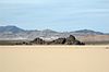
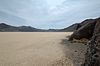
The Racetrack and the Grandstand seen from the road
The Racetrack
|
|
The Grandstand and environs
The Racetrack
|
|
The Grandstand and a view to the northwest
The Racetrack
|
|
|
|
|
|
|
|
|
|
|
|
Michelle on the playa
The Racetrack
|
|
Looking south from the base of the Grandstand
The Racetrack
|
|
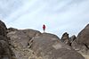
Michelle on the Grandstand
The Racetrack
|
|
|
|
|
|
|
|
|
|
|
|
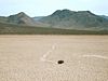
Racing rock
The Racetrack
|
|
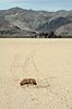
Racing rock with mud pileup, and track leading toward the Grandstand
The Racetrack
|
|
Nearly submerged racing rock, with Grandstand in the distance
The Racetrack
|
|
|
|
|
|
|
|
|
|
|
|
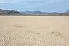
View to the southeast
The Racetrack
|
|
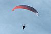
Powered paragliding
Furnace Creek
|
|
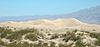
Dunes
Death Valley
|
|
|
|
|
|
|
|
|
|
|
|
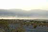
Dunes and the Grapevine range
Death Valley
|
|
Dunes and the Grapevine range
Death Valley
|
|
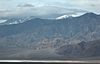
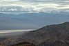
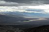
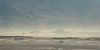
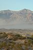
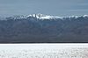
Panamint Valley, the Panamint range, and Telescope Peak
West of Panamint Springs
|
|
|
|
|
|
|
|
|
|
|
|
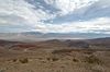
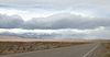
Panamint Valley and the Panamint range
Father Crowley Point
|
|
Panamint dunes, Telescope Peak, and Panamint Valley
Hunter Mountain road
|
|
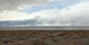
Dust plumes rising from Owens Lake bed just east of the Sierra
Lower Centennial Flat, east of Keeler
|
|
|
|
|
|
|
|
|
|
|
|
Dust plumes rising from Owens Lake bed
Keeler
|
|
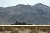
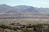
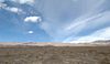
Our Explorer and the Inyo mountains
Keeler
|
|
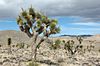
Joshua trees
On the Saline Valley road
|
|
|
|
|
|
|
|
|
|
|
|
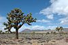
Joshua trees
On the Saline Valley road
|
|
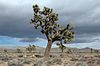
Joshua trees
On the Saline Valley road
|
|
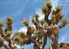
Joshua tree
On the Saline Valley road
|
|
|
|
|
|
|
|
|
|
|
|
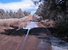
Allen checking the depth of the flooded road.
Snow lingers along the right-hand edge
Hunter Mountain Road
|
|
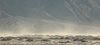
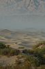
High winds raising sand from the dunes
Death Valley
|
|
High winds raising sand from the dunes
Death Valley
|
|
|
|
|
|
|
|
|
|
|
|
High winds raising sand from the dunes
Death Valley
|
|
Dunes
Death Valley
|
|
Dunes and the Grapevine range
Death Valley
|
|
|
|
|
|
|
|
|
|
|
|
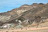
Artist's Drive
Death Valley
|
|
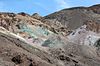
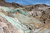
Artist's Palette
Death Valley
|
|
Artist's Palette
Death Valley
|
|
|
|
|
|
|
|
|
|
|
|
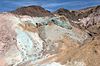
Artist's Palette
Death Valley
|
|
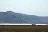
Badwater
Death Valley
|
|
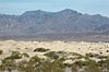
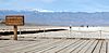
Telescope Peak seen from Badwater
Death Valley
|
|
|
|
|
|
|
|
|
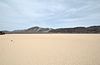
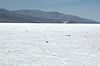
Badwater salt pan
Death Valley
|
|